 by
by Did you know that supercells are very rare but the most intense type of storm?
Supercells are known for a rotating updraft known as a mesocyclone. They can happen anywhere in the world. Yet, they are most common in the Great Plains of the U.S., also called Tornado Alley. These storms can bring hail, heavy rain, strong winds, and tornadoes.
To really grasp supercells, we need to look at their structure and what causes them. We should also explore where they happen most and the severe weather they create. Let’s dive into the world of rotating storms and learn more about supercells.
What Are Supercells?
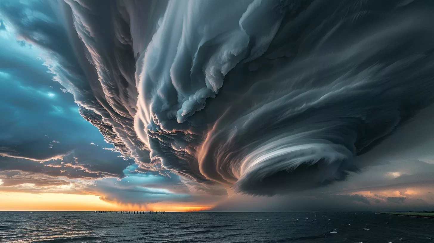
Supercells are thunderstorms with a deep, rotating updraft known as a mesocyclone. This rotation makes them different from other storms. They often stand alone and can control the weather around them for hours. Depending on their moisture content, supercells are labeled as classic, low-precipitation (LP), or high-precipitation (HP).
LP supercells are typical in dry areas, while HP ones are found in places with more moisture.
| Type | Precipitation Level | Climate |
|---|---|---|
| Classic Supercell | Varies | Varies |
| Low-Precipitation (LP) Supercell | Low | Arid |
| High-Precipitation (HP) Supercell | High | Moist |
The kind of supercell depends on how much rain it brings. Classic supercells’ rain can change a lot. LP supercells are common in dry places, and HP supercells in wet areas. These supercells can greatly affect local weather.
Supercells need specific conditions to form, like the right mix of buoyancy and wind shear. This mix lets them have a rotating updraft. Their structure and rotation make them capable of causing severe weather. This includes strong winds, big hail, and tornadoes.
Understanding supercells is key in predicting bad weather. Scientists and weather experts use tools like radar to watch and study these storms. This helps them warn people sooner and keep communities safe from danger.
Conservation and Supercells
Supercells are amazing to watch but they can harm nature and wildlife. They can destroy habitats and harm the environment. This is why saving and fixing ecosystems after storms is so important. It keeps our natural world thriving for years to come.
Characteristics of Supercells
Supercells are powerful thunderstorms with a knack for chaos. They come in various sizes and pack extreme weather. They bring large hail, heavy rain, strong winds, and downbursts.
These storms can last from 2 to 4 hours. While not all create tornadoes, many do. They form tornadoes from their rotating core called a mesocyclone.
Supercells are known for making big hail. Updrafts in the storm turn raindrops into ice. The ice then falls as hail, sometimes as big as golf balls.
They also drop a ton of rain. The rain can be so heavy that it leads to flash floods. This puts lives and homes at risk.
Along with hail and rain, supercells unleash strong winds. These winds can get over 100 mph, knocking down trees and buildings. The heavy winds add to the storm’s damage.
Supercells feature strong downdrafts too. These downdrafts hit the ground and spread out fast. They can create straight-line winds that wreak havoc.
We must understand supercells to stay safe. Keep an eye on the weather and listen to experts to protect yourself from these storms.
| Component | Description |
|---|---|
| Mesocyclone | A rotating updraft at the core of the supercell. |
| Updraft | A vertical, rapidly ascending current of air. |
| Downdraft | A column of cool, descending air within the storm. |
| Hail | Ice pellets in the form of layered precipitation. |
| Rainfall | Intense precipitation resulting from the updrafts. |
| Winds | Strong, destructive winds associated with the storm. |
| Downbursts | Rapidly descending and spreading pockets of cool air. |
Geography of Supercells
Supercells are severe storms that can form tornadoes. They happen around the world but are most common in the central United States. This area, known as Tornado Alley, sees a lot of these storms.
The Great Plains are perfect for supercells because of flat land and moisture from the Gulf of Mexico. This area’s geography helps severe thunderstorms grow.
Supercells are more common in Tornado Alley due to warm, wet air from the south meeting cool, dry air from the north. This mix makes the air unstable and helps create big storms.
But, supercells also happen outside of Tornado Alley, in places like Europe, South America, and Asia. Countries like Argentina, India, and Australia see these storms too.
Supercells Outside of Tornado Alley and the Great Plains
Supercells also occur outside the central U.S., in many different areas. These storms are shaped by the local weather and land.
In Europe, countries like the UK and Italy see supercells during bad weather. Southern Europe often has these big storms that can cause tornadoes.
In South America, places like Argentina and Brazil experience supercells in warmer months. These storms bring hail, rain, and sometimes tornadoes.
Asian countries, especially Bangladesh and India, get supercells in the monsoon season. Hot, moist air helps these storms form.
Supercells also occur in South Africa and Australia, showing they can happen in various climates. Australia’s eastern coast is one area affected by these storms.
While Tornado Alley has many supercells, it’s important to know these storms can form worldwide. This shows the wide reach and impact of supercells.
Supercell Anatomy
Supercell anatomy includes a mesocyclone and a downdraft. A mesocyclone is a rotating updraft, caused by wind shear. This rotation leads to a strong updraft in the supercell. The downdraft, on the other hand, is air sinking behind the storm.

A mesocyclone makes a supercell special, setting it apart from other storms. Its rotation leads to unique, powerful weather events.
For a supercell to form, there must be a cap, or capping inversion. This is warm air aloft, stopping air from going up. Once the cap breaks, the supercell can grow quickly.
“The rotating updraft and downdraft are crucial components of a supercell’s structure, contributing to its longevity and ability to produce severe weather.”
To understand supercells is vital for weather prediction. By studying mesocyclones and downdrafts, meteorologists learn about storm formation and intensity. This knowledge helps give early warnings, keeping communities safe.
Ingredients for Supercell Development
To turn into a supercell, storms need specific things. They need buoyancy and wind shear to form and get strong.
Buoyancy
Buoyancy is when air can rise freely. It starts the storm’s updraft. Warm air rises, cools down, and forms clouds and rain. Although important, buoyancy alone doesn’t make supercells.
Wind Shear
Wind shear is vital for supercells. It causes the storm’s updraft to spin. Wind shear means the wind’s speed or direction changes with height. It makes supercells different from normal storms. It forms the mesocyclone, the storm’s spinning heart.
“Wind shear is crucial for supercell storms. It gives them their spin and structure. Without it, there would be no supercell.”
Wind shear also keeps the storm’s updraft and downdraft separate. This makes the supercell last longer and stay strong. Warm air goes up, cool air comes down. Their interaction fuels the storm’s power.
Other weather conditions also matter for supercells. Moisture, instability, and how fast temperature changes with height affect their strength.
“Buoyancy and wind shear together make perfect conditions for supercells. Knowing this helps experts predict and follow these intense storms.”
Types of Supercells
Supercells vary in forms, each unique in its way. Knowing these types helps meteorologists eye severe weather. We’ll look into classic, high precipitation (HP), and low precipitation (LP) supercells.
Classic Supercells
Classic supercells are the ones you see in textbooks. They look like lone storm systems. They’re known for their spinning updraft, the mesocyclone. Such supercells can bring strong winds, giant hail, and tornadoes.
High Precipitation (HP) Supercells
HP supercells form in moist air. They’re the dark, heavy rain storms. The moisture can cause floods. HP supercells also bring winds, hail, and tornadoes.
Low Precipitation (LP) Supercells
LP supercells have less rain and form in dry places. They still bring the risk of big hail. These supercells are common in dry or drought-affected areas.
Different supercells let meteorologists predict weather more accurately. Each type, with its features and risks, helps issue warnings. Knowing them can keep people safer during severe weather.
| Type | Appearance | Precipitation | Associated Risks |
|---|---|---|---|
| Classic Supercell | Isolated storm system | Moderate to heavy | Strong winds, large hail, tornadoes |
| High Precipitation (HP) Supercell | Rain-wrapped storm system | Intense | Damaging winds, large hail, tornadoes, flash flooding |
| Low Precipitation (LP) Supercell | Drier appearance | Reduced | Large hail |
These supercells show the diverse severe weather they can cause. Meteorologists study moisture, structure, and other things to understand supercells. Better predictions help communities stay safe and reduce risks during bad weather.
Supercell Evolution and Transitions
Supercells have a unique structure and can be very destructive. They change types due to environmental conditions and their movement in the storm system. These changes greatly impact their strength and behavior.
An LP supercell can turn into a classic supercell in different conditions. This change affects its structure and how it acts. It also impacts weather events like tornadoes.
These transitions show the power of supercells to adapt. Scientists study these changes to predict storms better. This helps communities prepare for severe weather.
“Supercells are dynamic systems that possess the ability to respond and adapt to changes in their surroundings. These transitions highlight the complex nature of storm evolution and the intricate interplay between atmospheric conditions and storm behavior.”
Researchers look at how supercells work and their effects on the environment. Learning about supercells helps improve weather warnings. This means people can be safer during extreme weather.
Environmental Factors and Transitions
Many environmental factors can cause supercells to change. Wind shear and buoyancy are especially important. They influence how the storm grows and maintains its rotation.
- Buoyancy: This is how well air parcels can rise. It affects the storm’s intensity and structure.
- Wind Shear: This refers to changes in wind speed or direction. It’s crucial for the storm’s rotating updraft. Changes in wind shear can change the storm’s type.
Temperature, humidity, and atmospheric caps also play roles in these transitions. Understanding these factors helps forecast severe weather better.
Supercell Transitions
| Initial Type | Transition | Resultant Type |
|---|---|---|
| Low Precipitation (LP) | Environmental conditions becoming more favorable for precipitation | Classic Supercell |
| Classic Supercell | Changes in wind shear or moisture levels | High Precipitation (HP) Supercell |
| High Precipitation (HP) Supercell | Decrease in moisture levels or changes in the surrounding environment | Low Precipitation (LP) Supercell |
Supercell transitions highlight the complexity of storm systems. By understanding these changes, meteorologists can predict weather more accurately. This helps protect people and property.
Radar and Visual Identification of Supercells
To predict and understand severe weather, identifying supercells is key. Both radar and visual cues help us see supercell signs.
Radar Depiction
Supercells show distinct radar features that help spot them. A common sign is the hook echo. This curved shape on radar shows a storm’s mesocyclone, hinting at possible tornadoes. Supercells may also have a weak echo region (WER) or a bounded weak echo region (BWER). These show lower radar signals where the updraft is. Look for the V-notch too, showing a strong downdraft.
For more on radar signs of supercells, see the National Weather Service’s guide.
Visual Identification
Seeing supercells can also reveal their presence. Look for a wall cloud. This is where the storm’s mesocyclone is, and it often spins. A rain-free base shows where uplift happens, under the storm. The rear flank downdraft looks dark and stormy, showing where downdraft meets mesocyclone.
For tips on seeing these signs yourself, check meteorology guides and resources.

“Knowing radar and visual signs of supercells helps track these strong storms. Understanding them lets meteorologists warn us about possible dangers.”
| Feature | Indication |
|---|---|
| Hook Echo | Potential tornado development |
| Weak Echo Region (WER) | Reduced radar reflectivity near updraft |
| Bounded Weak Echo Region (BWER) | Localized area of reduced reflectivity |
| V-Notch | Strong rear flank downdraft |
| Wall Cloud | Lowering of cloud base, potential mesocyclone presence |
| Rain-Free Base | Area beneath the storm without precipitation |
| Rear Flank Downdraft | Dark, turbulent area where downdraft and mesocyclone interact |
| Updraft and Downdraft Separation | Visible distinction between the two regions |
Supercells and Severe Weather
Supercells are known for causing severe weather like damaging winds, large hail, and tornadoes. These storms have a unique structure that allows them to rotate persistently. This makes them very capable of causing extreme weather.
“Supercells are major threats in terms of severe weather. They can bring wind gusts that exceed 100 miles per hour. Such winds have the power to uproot trees, damage buildings, and send debris flying dangerously.”
Another danger from supercells is large hailstones. These hailstones can be as big as golf balls or even grapefruits. They can cause a lot of damage to properties and harm people outside during a storm.
“The strong updrafts in supercells cause hailstones to grow large. These updrafts lift the hailstones up into the storm. There, they collect supercooled droplets, which freeze and make the hailstones bigger.”
Supercells are also known for producing tornadoes. Although not every supercell makes a tornado, the worst tornadoes usually come from them. The rotation within a supercell creates the right conditions for tornadoes to form.
Because of this, meteorologists and storm chasers keep a close eye on supercells. They watch for signs that a tornado might develop.
Supercell Severe Weather Statistics
| Tornadoes | Large Hail | Damaging Wind |
|---|---|---|
| 80% of strong to violent tornadoes occur in supercells | Supercells are responsible for over 70% of large hail events | Supercells contribute to the majority of damaging wind reports |
| Supercells are the primary tornado producers | Supercells can produce hailstones larger than 2 inches in diameter | Wind speeds in supercell thunderstorms can exceed 100 mph |
These statistics show how important supercells are in severe weather events. They are key in causing wind damage, large hail, and tornadoes. Understanding supercells helps meteorologists predict and lessen the damage from these dangerous weather events. This helps keep communities safer.
Conclusion
Supercells are strong storms that twist and turn in the sky, bringing severe weather. They are key in creating tornadoes. To predict these dangerous storms, it’s vital to know how supercells work.
In the central United States, supercells are commonly seen. This area, known as Tornado Alley, is perfect for these storms. The right mix of weather and land features makes it happen.
Studying supercells helps us understand bad weather better. This knowledge can save lives by improving tornado alerts. It leads to fewer deaths and less damage.
We must take care of our planet to keep our weather safe. Changes in our climate can make supercells worse. By reducing harmful gases and following green practices, we can protect our future.